
The Big Dig -
Early in 2015 The Long Preston Heritage Group (LPHG) started plans to carry out an archaeological dig in Long Preston over 3 weekends in May 2015. The digs were planned to comprise a test pit about one metre square going down to about one metre. This type of dig has proved successful around the country as evidenced by Time Team. The aim was to see if we can find the reasons why Long Preston started where it did including whether there was any evidence of Long Preston being once an Anglo-
The LPHG had been researching the idea for some time and already had active academic support for the idea. This was from Dr Carenza Lewis of Cambridge University (who used to be on Time Team) as well as Chester University Archaeology Department. The digs would be led by Dr David Johnson who lives in Settle and who has already conducted successful digs around Ingleborough uncovering Anglo-
Virtually all village digs have taken place in the south or south east of England. However archaeologists are only now realising they are missing major parts of Britain’s story in that they simply do not know for definite what happened in most of the country. This is why there was such interest in a dig in Long Preston from the various universities. What we might find could throw new light on not just how Long Preston started but how and when the Anglo-
The historical Newsletter Updates
for the Big Dig Project can be read here:
Two Publications on the Big Dig Project
can be ordered here:
Summary Results of The Big Dig Project
This is a summary of the archaeological results from our archaeologist, David Johnson’s talk on Monday 24 Oct 2016. There were a large number of slides which have been condensed here to some of those showing the archaeological results.
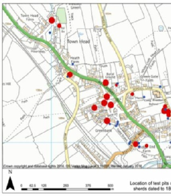
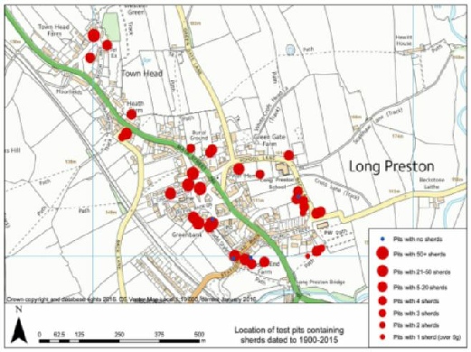
A total of 38 test pits have been dug. The sites were chosen not at random but based on the historical layout of the village. Villages were traditionally contained within Back Lanes. Long Preston has two. There is one in the east from the green near the Maypole pub past the school to the Church. The other, in the west, is near the railway. This second one has probably moved because of the railway and would have been nearer the village. Mediaeval (medieval is the normal form these days) tofts (houses) and crofts (associated fields) would normally be within the Back Lanes.
Other factors taken into account were the village core and modern developments. Slide ‘Location of Test Pits’ shows a gap in the middle. This is the auction mart and therefore archaeological records ‘trashed’. Otherwise there is a good spread throughout the village.
Main archaeology aim of the digs was to further knowledge of Long Preston before 1066. The name Preston drives from Anglo Saxon Preosta or priest and ‘tun’. ‘Tun’ originally meant fence but evolved into fenced enclosure, then farmstead, then a collection of farmsteads and eventually village. It is thought places ending in -
Geophys has also been conducted.
Firstly in the field between the Church, the A65 and Long Preston Beck. The area surveyed was at the bottom of the field by the Beck and detected a structure but not known what.
Secondly in a field which is marked with a red star in the top centre of the first slide. There is a mound among the ploughed terraces. This area has been surveyed twice. The first detected something but was not enough to say it was a burial mound.
The second survey covered a wider area but this showed nothing structural, except the ploughed terraces, although, again, there was a hint of something in the middle where the mound is.
The third survey area was in the field alongside Toddstiles, marked with a green star on the location slide towards the bottom. Again medieval ploughed terraces were found together with some magnetic signals one quite large towards the field wall in the centre of the field.
From the digs, there were 4002 small finds which were:
- Pottery sherds 2326
- Metal objects 225
- Glass objects 314
- ‘Industrial debris’ 481 eg coal, slag, clinker
- Clay tobacco pipe pieces 257
- Ceramic building materials 120
- Lithics 55 ie prehistoric worked stone
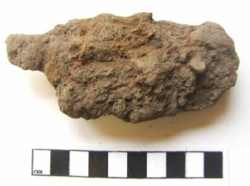
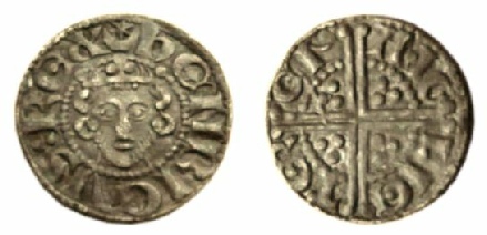
Slide 2 Shows a knife blade, found in Pit 12 in a garden on Station Road,
in its original and cleaned up states.
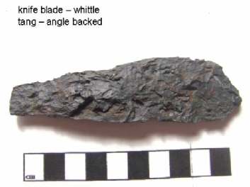
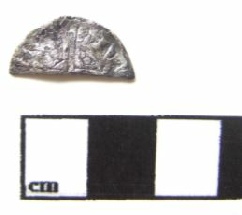
Slide 3 From Pit 14 just off Main Green, shows a half coin and what it might have looked like before being cut. It is a ‘voided long-
In the same pit was an encrusted silver spoon bowl probably from the 18 Century. It is interesting that there is silver in the same pit from 500 years apart.
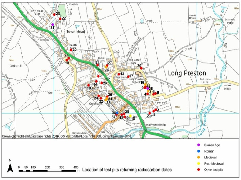
It was decided to carbon date 10 charcoal samples of which 1 failed.
- 2 were Bronze Age (1047 – 898 BC and 1116 -
971BC) - 1 was Roman period (AD 134 -
330) - 5 were mediaeval (1043-
1224, 1159- 1257, 1281- 1384,
1295-1403 and 1302- 1367) - 1 post mediaeval (1625-
1669)
Carbon dating gives a determination ‘BP’ , ie Before Present, Before 1950.This raw data is then checked against tree rings to arrive at a ‘calibrated date’. The distribution is shown below in Slide 4. These and the other results tell us how the village developed.
The lithics.
Of the 55 pieces found, 44 were worked and 9 were definitely flint. They were found mainly around the Church, Station Road / Long Preston Beck and Townhead.
75%, or 35 pieces, were burnt and all these came from Pit 14 (where the half coin and spoon were found). This probably indicates they were from a fire pit, probably Mesolithic, 6000 to 8000 years ago.
It is probable that the fire pit, about 1 metre diameter by 1.5 metre deep, would have heated sandstone to go into water to heat for cooking. At this time people were nomadic or semi-
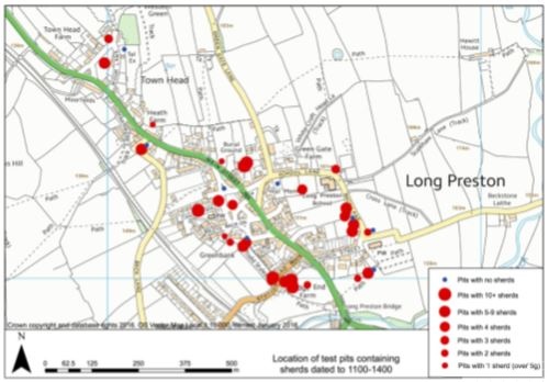
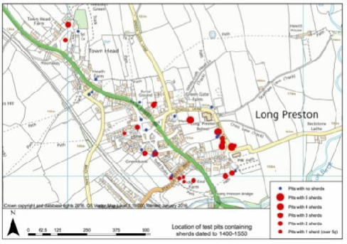
This also shows the comparison between finds from the High Mediaeval and Late Mediaeval (1400 to 1550) periods. The finds have decreased considerably in number and distribution.
The years 1315 to 1318 were subject to harvest failures, plague and Scottish raids. The climate was worsening and becoming much wetter leading to land being converted from arable to pasture. You don’t need to spread manure for pasture land as much.
Slide 6 High Mediaeval Period.
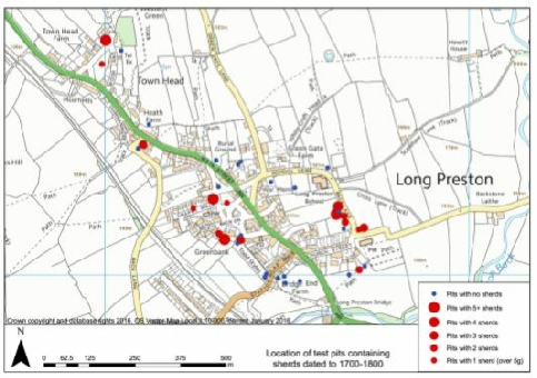
Also on Slide 7 is the Post Modern period from 1700 to 1800. This shows a shrinkage again which probably reflects technological developments, including Staffordshire pottery.
Vernacular pottery didn’t break as much although, maybe, people couldn’t afford modern pottery.
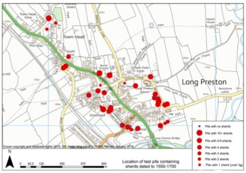
Slide 7 The Post-
Slide 8 The two Modern Periods.
Firstly from 1800 to 1900 there are some gaps but, by this time, the fields were pasture and grazing land.
Post-
Other points to note.
The glass found in the pits included
- A Roman glass ‘cup’ from the 2nd to 3rd century.
- There was also much 18th century glass
- 41 fragments of late 16th and 17th century thin window glass, some with lead came traces.
- 53 fragments from20 pits of late 17th to 18th century dark olive green (wine) bottle glass.
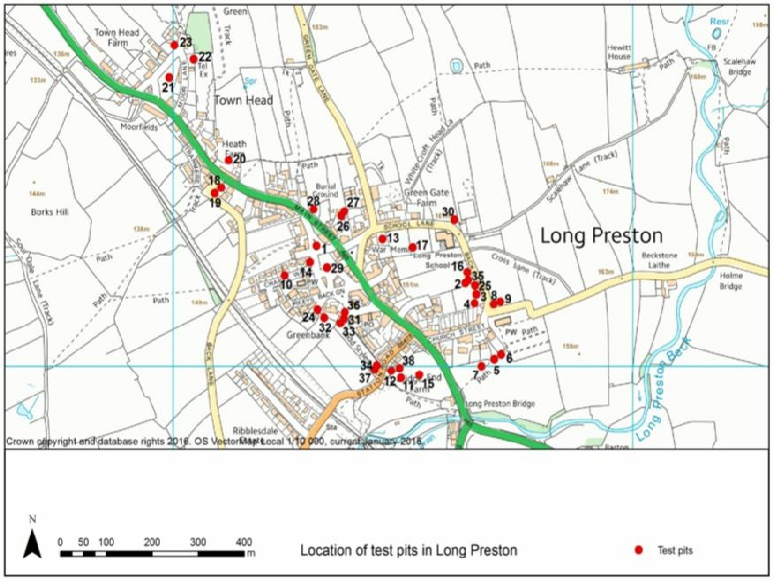
In the building materials were Welsh slate, brick, floor tiles, etc but also, from Pit 3, 5 and 17, 7 fragments of daub.
This concludes the summary of the talk.
David Johnson, our archaeologist for the project,
has produced a detailed and well illustrated report,
consisting of 148 A4 size pages,
which gives full details of all the finds in all of the pits.
This is available to buy at £7.50 + P&P
The Long Preston Heritage Group will be producing a summary of this report
and try to set the dig results into a wider context.
The owners will be getting a report on their own pits in due course.


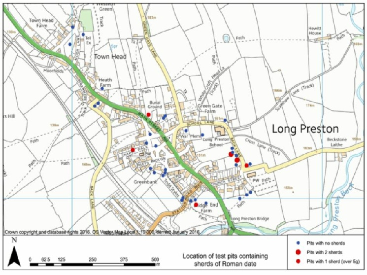
Slide 5 The Roman Period ( 70 -
For the Roman period most finds were native pottery although one piece was Samian ware imported from Gaul, and one piece was from a glass drinking vessel. This does not mean Romans were in Long Preston but that there was activity in Long Preston in the Roman period mainly near the Church.
Finds were made in 31 of the 38 pits and broadly matches the charcoal distribution pattern, ie around the Back Lanes and Church. If the finds came from near the toft, it would be a waste product. If at a distance, it would have gone into a midden with food and other waste to be spread on the fields as fertiliser.
Generally the quality of the topsoil was first class which indicates that there was a large population and ploughing.
In a lot of pits, diggers noticed a layer of cinders. This is thought to be from cinders going into the midden and then being spread.
There could also have been population decline which would lead to less farmland and less spreading from middens. Also, although unlikely, less pottery could be being used.
In the Post-
At this time people could afford tobacco even though the 1618 Ale act banned tobacco sales. Of the 257 clay tobacco pipe pieces found throughout the village, 9, over a third, were from one pit, number 31, Greenbank Cottage. That area produced the largest number of finds maybe indicating a relatively wealthy area.